The island Avery is continuously imagining and depicting is a believable, fixed and detailed geographical setting with familiar features such as seas, mountains, plains, forests, markets, a capital city, a port, and large corporations. Avery is set on making his imagined archipelago a coherent space, as he suggests in an interview with Metropolis magazine:
“Firstly, I am slowly constructing, (…) a physical 3D map of the world, so that I might navigate it freely. This model is not intended as an artwork, but as a tool for me to use, so that when I draw a view from one part of the island, it will be exactly coherent with a view from another part of the island – that is to say, all of the mountains will be in the right place.
“If somebody very clever wanted to, they could infer from all my drawings the rough shape and dimensions of the world without having seen the model. We will go further and build the town and all other permanent features, including the fixed Gods. This internal coherence, both on a physical and logical sense, I feel is essential to the credibility of the project. In terms of detail, I will use the device of describing certain features in fastidious detail, but leaving swathes of the island lightly outlined.”2
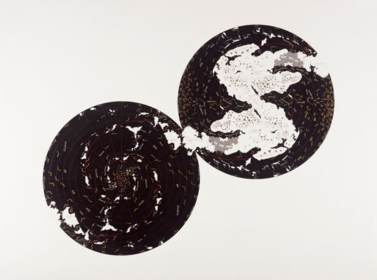
The map above shows the archipelago of islands connected by the ‘wetlands’ called the Qoro Qoros. These act like a point of origin for The Island where all of Avery’s taxonomically impossible creatures are born, yet also where all natural and philosophical systems break down. Oddly enough, the explorers and tourists from Triangland travel to The Island by sea, falsely assuming that their worlds are separate.
The imagined separation between Trinagland and The Island serves to symbolize a central exploration in Avery’s project. By opposing these two entities, Avery makes visible the paradoxes inherent in the very structures and philosophies we use to explain our own world: “via the Islanders we come face to face with the absurdity of the world as we know it.”
The Port of Onomatopoeia is both a point of arrival and departure in the overall geography of The Island. It is where passenger liners and merchant vessels containing The Island’s colonists arrive, and from where hunting expeditions to find the Noumenon depart. Onomatopoeia is the main town, and as such it contains all the main bazaars and tourist attractions such as The Plane of the Gods. Avery’s drawings are full of art historical and cultural references, and if you look carefully you may spot J.D Sallinger, Bill Murray or Kublai Khan, the Mongol emperor who met with Marco Polo.
The port is also inspired by historical figures and epochs such as the large ‘Penrose’ building, a tribute to British mathematician and physicist, Roger Penrose. Avery has described the general allure of the town as a mix between Victorian England, the Scottish Highlands and London’s East End. In Onomatopoeia: The Port Avery points out:
“It is true to say of Onomatopoeia that it is a poor place generally. A large part of the population lives in shanty dwellings. But then there are the dapper and idle rich … I see the Island as a one time terra incognita, and Onomatopoeia as an outpost, turned boomtown, turned vulgar theme park, then as a depression hit slum, and so on.”3
The English colonial style and early 20th-century aesthetic are constant throughout Avery’s drawings, and he admits that this was a deliberate decision. Avery’s urban scenes are both incredibly detailed and seemingly unfinished at the same time; his ghost-like characters lend a seductive and precarious quality to his drawings.
View an image of Untitled (View of the Port at Onomatopoeia)
1 Avery, “Onomatopoeia, the Port.” p.160.
2 Tate, “Charles Avery”, 27/03/13, http://www.tate.org.uk/art/artworks/avery-untitled-view-of-the-port-at-onomatopoeia-t13392/text-summary
3 Avery, “Onomatopoeia, the Port.” Epilogue.
